Updating search results...

Search Resources

3918 Results

View
Selected filters:
  • Science Education Resource Center (SERC) at Carleton College
The Epicenter of a Southwestern Earthquake
Conditional Remix & Share Permitted
CC BY-NC-SA
Rating
0.0 stars

This activity guides students to use the measured difference in P and S wave velocities to locate the epicenter of a minor earthquake in the Southwestern United States.

Click here to view the full activity on the KÃyah Math Project website.

(Note: this resource was added to OER Commons as part of a batch upload of over 2,200 records. If you notice an issue with the quality of the metadata, please let us know by using the 'report' button and we will flag it for consideration.)
Subject:
Biology
Geoscience
Life Science
Physical Science
Material Type:
Activity/Lab
Provider:
Science Education Resource Center (SERC) at Carleton College
Provider Set:
Teach the Earth
Author:
KÃyah Math Project development team: Nancy Zumoff, Christopher Schaufele, Steven Semken, Tracy Perkins, Lynn Onken, Philippe Laval, David Gonzales, and Andrew Becenti (deceased). KÃyah Math Project directed by Steven Semken , Arizona State University; and Christopher Schaufele and Nancy Zumoff, Professors of Mathematics, Emeritus. Archived at Arizona State University School of Earth and Space Exploration.
Date Added:
09/25/2022
Episodic tremor and slip: The Case of the Mystery Earthquakes | Lessons on Plate Tectonics
Conditional Remix & Share Permitted
CC BY-NC-SA
Rating
0.0 stars

Earthquakes in western Washington and Oregon are to be expected -- the region lies in the Cascadia Subduction Zone. Offshore, the Juan de Fuca tectonic plate subducts under the North American plate, from northern California to British Columbia. The region, however, also experiences exotic seismicity -- Episodic Tremor and Slip (ETS).In this lesson, your students study seismic and GPS data from the region to recognize a pattern in which unusual tremors--with no surface earthquakes--coincide with jumps of GPS stations. This is ETS. Students model ductile and brittle behavior of the crust with lasagna noodles to understand how properties of materials depend on physical conditions. Finally, they assemble their knowledge of the data and models into an understanding of ETS in subduction zones and its relevance to the millions of residents in Cascadia.

(Note: this resource was added to OER Commons as part of a batch upload of over 2,200 records. If you notice an issue with the quality of the metadata, please let us know by using the 'report' button and we will flag it for consideration.)
Subject:
Biology
Life Science
Mathematics
Measurement and Data
Statistics and Probability
Material Type:
Activity/Lab
Provider:
Science Education Resource Center (SERC) at Carleton College
Provider Set:
Teach the Earth
Author:
Shelley Olds
Date Added:
08/27/2022
Equation Dictionary
Conditional Remix & Share Permitted
CC BY-NC-SA
Rating
0.0 stars

When equations are presented in class or in the context of textbook reading, students first evaluate whether the equation is appropriate for use in the dictionary (is it useful in many situations or specific to one problem? Is it a "final" version of an equation, or can it be simplified? Is it likely to be used in solving geophysical problems?) Once an equation is selected for the dictionary, students add a "definition" that includes (a) a short description of each variable and relevant constants, including appropriate units, (b) a written description of the process or relationships presented within the equation, and (c) any additional notes that help them understand the equation. The dictionary may be used on homework and exams, which encourages students to describe the equations in a manner that is meaningful to them. Thus, rather than simply write down the equation for seismic moment, a student might add "Seismic moment is a function of the size of the fault as well as the rigidity of the rock. The larger the fault or the displacement, the larger the earthquake". This activity allows students to evaluate their understanding of equations and the underlying physical processes.
Addresses student fear of quantitative aspect and/or inadequate quantitative skills
Addresses student misconceptions

(Note: this resource was added to OER Commons as part of a batch upload of over 2,200 records. If you notice an issue with the quality of the metadata, please let us know by using the 'report' button and we will flag it for consideration.)
Subject:
Biology
Life Science
Material Type:
Homework/Assignment
Provider:
Science Education Resource Center (SERC) at Carleton College
Provider Set:
Teach the Earth
Author:
Jackie Caplan-Auerbach
Date Added:
09/05/2020
Equilibrium Experiment
Conditional Remix & Share Permitted
CC BY-NC-SA
Rating
0.0 stars

Students explore the systems thinking concepts of equilibrium and nonequilibrium with a water pouring experiment. Students complete the activity at home or virtually with videos. Water is poured from a top container (reservoir) into a central cup (reservoir) with a small hole for water outflow at a different rate in each trial. Students observe what happens to the water level in the central container, graph the change in water level over time, and assess whether the central reservoir was in equilibrium or nonequilibrium for each trial.

Subject:
Physical Science
Physics
Material Type:
Activity/Lab
Provider:
Science Education Resource Center (SERC) at Carleton College
Provider Set:
Teach the Earth
Author:
Cameron Weiner
Date Added:
01/20/2023
Erosion in Our World
Conditional Remix & Share Permitted
CC BY-NC-SA
Rating
0.0 stars

This activity is a field investigation where students find real-life examples of erosion in their school surroundings. Students will extend what they learned during stream table lessons about erosion, deposition, deltas, meandering streams, and dams.

Subject:
Geology
Physical Science
Material Type:
Activity/Lab
Provider:
Science Education Resource Center (SERC) at Carleton College
Provider Set:
Pedagogy in Action
Author:
Abbey Payeur
Date Added:
08/16/2012
Erosion in Our World
Conditional Remix & Share Permitted
CC BY-NC-SA
Rating
0.0 stars

This activity is a field investigation where students observe evidence of erosion and deposition in the schoolyard or designated area.

Subject:
Geology
Physical Science
Material Type:
Activity/Lab
Provider:
Science Education Resource Center (SERC) at Carleton College
Provider Set:
Pedagogy in Action
Author:
Erin Leitner
Date Added:
08/16/2012
Erosion in a River
Conditional Remix & Share Permitted
CC BY-NC-SA
Rating
0.0 stars

Formative assessment questions using a classroom response system ("clickers") can be used to reveal students' spatial understanding.
Students are shown these diagrams and instructed to "Click in the river where you expect to find the greatest rate of erosion along the river bed."
A follow-up question asks students to "Click in the river where you expect to find the fastest moving water."

(Note: this resource was added to OER Commons as part of a batch upload of over 2,200 records. If you notice an issue with the quality of the metadata, please let us know by using the 'report' button and we will flag it for consideration.)
Subject:
Biology
Life Science
Material Type:
Activity/Lab
Assessment
Provider:
Science Education Resource Center (SERC) at Carleton College
Provider Set:
Teach the Earth
Author:
Nicole LaDue
Date Added:
09/28/2022
Erosion of the Grand Canyon
Conditional Remix & Share Permitted
CC BY-NC-SA
Rating
0.0 stars

Students estimate the volume of the Grand Canyon to calculate the average rate of erosion of the canyon, assuming the canyon began to form approximately 6 million years ago. They then find out how much sediment the Colorado River is actually carrying, in cubic feet per year, and compare that to their calculated value. In the process of calculating the rate of erosion, they face multiple unit conversions. I also challenge them to convert their answer into units they can visualize, such as Olympic swimming pools of sediment per day.

(Note: this resource was added to OER Commons as part of a batch upload of over 2,200 records. If you notice an issue with the quality of the metadata, please let us know by using the 'report' button and we will flag it for consideration.)
Subject:
Biology
Life Science
Material Type:
Activity/Lab
Provider:
Science Education Resource Center (SERC) at Carleton College
Provider Set:
Teach the Earth
Author:
Carol Ormand
Date Added:
09/01/2022
Establishing relevance as a way to motivate introductory students
Conditional Remix & Share Permitted
CC BY-NC-SA
Rating
0.0 stars

Introduction to Geology students are asked to write a two page (5-6 paragraph) editorial that addresses what geology is and why it is important to society. To gather the information for their editorial, students have to interview at least five individuals (two of whom have to be professionals or faculty members), and consult the mission statements and goals of professional geology organizations (i.e. AAPG, AGU, GSA, SEPM, etc.) Students then synthesize their research and construct a well-written editorial with appropriate citations that will either explain, persuade, criticize, or praise. In completing the assignment, students not only better understand why it is good to study geology, but also have an appreciation for the scope and content of an Intro to Geology course.
Teaching Tips
Adaptations that allow this activity to be successful in an online
environment
I have not used this activity in an online environment, although students in my face-to-face class submit their assignment online through learning management software (i.e. BlackBoard, Desire2Learn, etc.).

Elements of this activity that are most effective
This is effective because it requires that students become active in the learning process, and although the writing is minimal, they have to really pay attention to their wording, point of view, and purpose. Moreover, when students interview professionals, other faculty, their parents, or friends, they are often engaged in interesting conversations that provide important insights. I have found that this helps motivate students and excites them about the content of the course.

Recommendations for other faculty adapting this activity to their
own course:
I recommend that other faculty use the content of the editorials periodically by referring back to student responses throughout the duration of their courses. It helps draw students back into the course, and helps connect them to why they are studying geology in the first place. In years when written work are less than satisfactory, I often require students to swap editorials and provide peer critiques. This usually helps students who struggle with their writing.

(Note: this resource was added to OER Commons as part of a batch upload of over 2,200 records. If you notice an issue with the quality of the metadata, please let us know by using the 'report' button and we will flag it for consideration.)
Subject:
Biology
Life Science
Material Type:
Activity/Lab
Homework/Assignment
Provider:
Science Education Resource Center (SERC) at Carleton College
Provider Set:
Teach the Earth
Author:
Sean Cornell
Date Added:
03/27/2020
Estimating Areal Rainfall in the Lake Whatcom Watershed
Conditional Remix & Share Permitted
CC BY-NC-SA
Rating
0.0 stars

The learning objectives for this GIS exercise are to 1) understand rainfall spatial variability and how to account for it when making areal-rainfall estimates, and 2) learn how ArcGIS can be used as a tool to determine areal averages, and 3) compare the advantages and drawbacks of the various techniques.

(Note: this resource was added to OER Commons as part of a batch upload of over 2,200 records. If you notice an issue with the quality of the metadata, please let us know by using the 'report' button and we will flag it for consideration.)
Subject:
Biology
Hydrology
Life Science
Physical Science
Material Type:
Activity/Lab
Provider:
Science Education Resource Center (SERC) at Carleton College
Provider Set:
Teach the Earth
Date Added:
08/27/2019
Estimating Discharge from Ares Vallis Using Pathfinder Images and MOLA Topography
Conditional Remix & Share Permitted
CC BY-NC-SA
Rating
0.0 stars

On July 4th, 1997, Mars Pathfinder landed at the mouth of Ares Vallis, a large channel that drains into the Chryse Planitia basin. While there remains a great deal to debate about the origin of the channels, one of the leading hypotheses at present is the idea that these features are the result of catastrophic flooding. If this is correct, then the plains where Pathfinder landed may be rich in debris eroded out of the Martian highlands across which the Ares Vallis channel passes, providing a golden combination -- a relatively safe landing site which still provides access to a wide variety of different rock types. [If you would like to learn more about the many Pathfinder results, explore the April, 1999 and January, 2000 issues of the journal Journal of Geophysical Research -- Planets (the green one) in the library.]

For the sake of this lab assignment you will hypothesize that the Ares Vallis and associated deposits were indeed produced by catastrophic flooding, and will use the information at your disposal to learn all you can about the putative flooding event.

(Note: this resource was added to OER Commons as part of a batch upload of over 2,200 records. If you notice an issue with the quality of the metadata, please let us know by using the 'report' button and we will flag it for consideration.)
Subject:
Biology
Hydrology
Life Science
Mathematics
Measurement and Data
Physical Science
Statistics and Probability
Material Type:
Activity/Lab
Provider:
Science Education Resource Center (SERC) at Carleton College
Provider Set:
Teach the Earth
Author:
Eric Grosfils
Date Added:
09/20/2022
Estimating Exchange Rates of Water in Embayments using Simple Budget Equations.
Conditional Remix & Share Permitted
CC BY-NC-SA
Rating
0.0 stars

Simple budgets may be used to estimate the exchange of water in embayments that capitalize on the concept of steady state and conservation principals. This is especially true for bays that experience a significant exchange of freshwater. This exchange of freshwater may reduce the average salt concentration in the bay compared to seawater if it involves addition of freshwater from rivers, R, and/or precipitation, P. Alternatively, it may increase the average salt concentration in the bay compared to seawater if there is relatively little river input and high evaporation, E. Since freshwater input changes the salt concentration in the bay, and salt is a conservative material, it is possible to combine two steady state budgets for a bay, one for salt and one for water, to solve for the magnitude of the water flows that enter and exit the bay mouth.
Students will make actual calculations for the inflow and outflow of water to Puget Sound, Washington and the Mediterranean Sea and compare them to actual measured values.

(Note: this resource was added to OER Commons as part of a batch upload of over 2,200 records. If you notice an issue with the quality of the metadata, please let us know by using the 'report' button and we will flag it for consideration.)
Subject:
Biology
Chemistry
Geoscience
Life Science
Mathematics
Measurement and Data
Physical Science
Statistics and Probability
Material Type:
Activity/Lab
Provider:
Science Education Resource Center (SERC) at Carleton College
Provider Set:
Teach the Earth
Author:
Keith Sverdrup
Date Added:
11/24/2020
Estimating GPS Positional Error
Conditional Remix & Share Permitted
CC BY-NC-SA
Rating
0.0 stars

After instructing students on basic receiver operation, each student will make many (10-20) position estimates of 3 benchmarks over a week. The different benchmarks will have different views of the skies or vegetation cover. Each student will download their data into a spreadsheet and calculate horizontal and vertical errors which are collated into a class spreadsheet. The positions are sorted by error and plotted in a cumulative frequency plot. The students are encouraged to discuss the distribution, sources of error, and estimate confidence intervals. This exercise gives the students a gut feeling for confidence intervals and the accuracy of data. Students are asked to compare results from different types of data and benchmarks with different views of the sky.
Uses online and/or real-time data
Has minimal/no quantitative component
Addresses student fear of quantitative aspect and/or inadequate quantitative skills
Addresses student misconceptions

(Note: this resource was added to OER Commons as part of a batch upload of over 2,200 records. If you notice an issue with the quality of the metadata, please let us know by using the 'report' button and we will flag it for consideration.)

Subject:
Biology
Life Science
Material Type:
Activity/Lab
Provider:
Science Education Resource Center (SERC) at Carleton College
Provider Set:
Teach the Earth
Author:
Bill Witte
Date Added:
08/12/2019
Estimating Greenhouse Gas Offsets as Part of Shoreline Community College's Greenhouse Gas Inventory
Conditional Remix & Share Permitted
CC BY-NC-SA
Rating
0.0 stars

This is a service-learning project for students in Geography 204 (Weather, Climate and Ecosystems). Students will assess prior estimates of carbon offsets associated with plant and soil biomass on their college campus; and as a result, they will understand the complexity of measuring the complex sources of carbon emissions and offsets; address the challenges of coordinating data collection and field measurement; and realize importance of estimation in public policy contexts.

(Note: this resource was added to OER Commons as part of a batch upload of over 2,200 records. If you notice an issue with the quality of the metadata, please let us know by using the 'report' button and we will flag it for consideration.)
Subject:
Applied Science
Biology
Environmental Science
Life Science
Mathematics
Physical Geography
Physical Science
Material Type:
Activity/Lab
Provider:
Science Education Resource Center (SERC) at Carleton College
Provider Set:
Teach the Earth
Author:
Charles Dodd, Shoreline Community College
Date Added:
11/14/2018
Estimating OUR Carbon Footprint
Conditional Remix & Share Permitted
CC BY-NC-SA
Rating
0.0 stars

Description here.

(Note: this resource was added to OER Commons as part of a batch upload of over 2,200 records. If you notice an issue with the quality of the metadata, please let us know by using the 'report' button and we will flag it for consideration.)

Subject:
Applied Science
Biology
Health, Medicine and Nursing
Life Science
Mathematics
Measurement and Data
Statistics and Probability
Material Type:
Activity/Lab
Provider:
Science Education Resource Center (SERC) at Carleton College
Provider Set:
Teach the Earth
Author:
Ben Galluzzo
Jean McGivney-Burelle
Rikki Wagstrom
Date Added:
05/19/2021
Estimating Primary Production in the Oceans from Satellite Data
Conditional Remix & Share Permitted
CC BY-NC-SA
Rating
0.0 stars

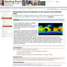
In this computer lab, students use satellite imagery, daylength information, and phytoplankton physiology models to calculate annual primary production for an assigned ocean region.

Satellite data is obtained from the NASA Earth Observation website. Students use the analysis tool to determine chlorophyll concentration and sea surface temperature. They also receive a day-length calculator and are asked to model light transmission through the water column. Using step-by-step instructions and proviede equations relating phytoplankton physiology to irradiance and temperature students calculate carbon uptake at discreet locations in the water column. The second half of the exercise involves scaling up to the entire water column, region, and season. Students present their work to the class and evaluate their result using scientific literature. Differences between regions are then discussed by the class.

(Note: this resource was added to OER Commons as part of a batch upload of over 2,200 records. If you notice an issue with the quality of the metadata, please let us know by using the 'report' button and we will flag it for consideration.)
Subject:
Biology
Chemistry
Geoscience
Life Science
Mathematics
Measurement and Data
Oceanography
Physical Science
Material Type:
Activity/Lab
Data Set
Lesson Plan
Provider:
Science Education Resource Center (SERC) at Carleton College
Provider Set:
Teach the Earth
Author:
Kevin Arrigo
Lindsey Kropuenske
Richa
Date Added:
06/16/2022
Estimating Valley Fill Thickness with a Gravity Survey
Conditional Remix & Share Permitted
CC BY-NC-SA
Rating
0.0 stars

Previous mapping exercises have dealt with well-exposed rocks, but this particular area runs into a problem with a thick valley fill on bedrock. We have some good estimates of the density contrast for the valley fill and bedrock. A prelab exercise asks the students to assign realistic densities to the units. In class we develop a model for the expected anomaly size for different thickness, then we go out and measure the anomaly and estimate the thickness.
Uses online and/or real-time data Has minimal/no quantitative component
Addresses student fear of quantitative aspect and/or inadequate quantitative skills
Uses geophysics to solve problems in other fields

(Note: this resource was added to OER Commons as part of a batch upload of over 2,200 records. If you notice an issue with the quality of the metadata, please let us know by using the 'report' button and we will flag it for consideration.)
Subject:
Biology
Life Science
Material Type:
Activity/Lab
Provider:
Science Education Resource Center (SERC) at Carleton College
Provider Set:
Teach the Earth
Author:
Bill Witte
Date Added:
08/12/2019
Estimating flow through an earthen dam
Conditional Remix & Share Permitted
CC BY-NC-SA
Rating
0.0 stars

Students make measurements of dam dimensions and water levels above and below a small, accessible earthen dam. They assess the soil texture in the field. They follow up by developing a simple flow net and estimating seepage rate as part of a problem set. They discuss their assumptions and the likely sources and magnitude of error.

(Note: this resource was added to OER Commons as part of a batch upload of over 2,200 records. If you notice an issue with the quality of the metadata, please let us know by using the 'report' button and we will flag it for consideration.)
Subject:
Biology
Hydrology
Life Science
Physical Geography
Physical Science
Material Type:
Activity/Lab
Provider:
Science Education Resource Center (SERC) at Carleton College
Provider Set:
Teach the Earth
Author:
Kaye Savage
Date Added:
08/06/2019
Estuarine Salinity Distribution and Classification Project
Conditional Remix & Share Permitted
CC BY-NC-SA
Rating
0.0 stars

This is a field and lab activity in which students collect CTD data in a local estuary, contour the data, and analyze the results to classify the estuary based on standard classification schemes.

(Note: this resource was added to OER Commons as part of a batch upload of over 2,200 records. If you notice an issue with the quality of the metadata, please let us know by using the 'report' button and we will flag it for consideration.)
Subject:
Biology
Life Science
Material Type:
Activity/Lab
Provider:
Science Education Resource Center (SERC) at Carleton College
Provider Set:
Teach the Earth
Author:
Brad Hubeny
Date Added:
08/09/2019
Ethical Dilemmas of Backcountry Skiing and Guiding
Conditional Remix & Share Permitted
CC BY-NC-SA
Rating
0.0 stars

This case study explores decision-making in high risk settings such as back-country skiing. The scenarios presented have application to many field-based studies where of physical injury or even death may be an outcome in circumstances that have known predictable risks that must be evaluated. Go? or No Go? What factors must be considered to ensure the safety of the group while achieving desired objectives? What are the ethical responsibilities of group leaders and group members in high-risk situations? Recommended readings on high-risk decision making are provided.

(Note: this resource was added to OER Commons as part of a batch upload of over 2,200 records. If you notice an issue with the quality of the metadata, please let us know by using the 'report' button and we will flag it for consideration.)

Subject:
Biology
Life Science
Material Type:
Activity/Lab
Case Study
Provider:
Science Education Resource Center (SERC) at Carleton College
Provider Set:
Teach the Earth
Author:
Dave Mogk
Date Added:
08/17/2022