This series is a charming and often humorous look at the contemporary …
This series is a charming and often humorous look at the contemporary life of a Cree community. Set in a fictitious community in northern Saskatchewan, the animation stories follow the exploits of young Raven, Talon and their cousin T-Bear as they face challenges and learn valuable life lessons.
Educators can use the series to teach children about Cree culture and about universal themes such as honouring tradition, cooperation, self-esteem and ethics. This series is also available in French and Cree versions.
Over the millennia, every region on Earth has developed its own successful …
Over the millennia, every region on Earth has developed its own successful agricultural ecosystem from flat fields of grain and mountainside rice terraces to coastal fish farms and goat herding. Today, we’re going to break down agricultural systems into three scales: subsistence, small-scale, and industrial agriculture. And we’ll take a look at how a place's history plays a huge role in the system we see today as we follow the story of agriculture in the Philippines.
Today we’re going to take a closer look at these beautiful but …
Today we’re going to take a closer look at these beautiful but dangerous landforms as we explore the different types of volcanoes and trace the patterns of volcanic activity around the world. From the explosive power of a stratovolcano like Mount St. Helens in Washington to the quiet but consistent eruptions of a shield volcano like Kīlauea in Hawaiʻi, volcanoes are like windows into the center of the Earth helping us understand more about how it all works.
From outbreaks of measles in the United States and cholera in Haiti …
From outbreaks of measles in the United States and cholera in Haiti to patterns of lead poisoning near gold mines in Nigeria, medical geographers play an important role in tracking disease in the landscape. Today, we're going to look at strategies medical geographers use to help as many people as possible achieve the highest level of health possible.
In addition to just being beautiful one-of-a-kind panoramas in the sky, clouds …
In addition to just being beautiful one-of-a-kind panoramas in the sky, clouds can tell us so much about how energy and weather patterns flow around the globe. Today, we'll talk about how clouds form, the three main types (cirrus, status, and cumulus), explain how and why we get rain, and end with a discussion on humidity and how high humidity can feel hot and sticky on a warm day but comfortable on a cold day. So join us and countless people throughout history and look up -- at the clouds!
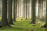
Today we're going to take a closer look at ecosystems -- which …
Today we're going to take a closer look at ecosystems -- which are communities of living organisms in an area interacting with their environment -- and how this relationship between the amount of energy a place receives and the movement of nutrients is what makes the incredible diversity of life possible. We'll also take a look at the patterns we see in the main global biomes, show you why some biomes (like tropical rainforests) are so productive, and discuss an agricultural practice some farmers have employed to help preserve their local ecosystems.
According to the UN, people living in urban places now outnumber those …
According to the UN, people living in urban places now outnumber those in rural areas — which is a pretty new phenomenon for many parts of the world. So today, we’re going to discuss factors that have led to this shift in populations from rural to urban residences (known as urbanization), and we’ll examine the historical and structural systems, like colonialism and Central Place Theory, that have influenced the cities we see today.
Correction: On the map here we incorrectly placed the Shanghai marker where Guangzhou is located.
In our final episode of Crash Course Geography we're going to take …
In our final episode of Crash Course Geography we're going to take a look towards the future, and to do that we'll need to revisit our fundamental geography tools: space, place, and human-environment interactions! We'll talk about the rise of the digital world and virtual spaces, the continued impacts of globalization and the Anthropocene, and even ponder new ideas like geoengineering. As we've said many times in this series the Earth is a beautifully dynamic place, and human innovation and our desire to claim and create our own places will continue to build new landscapes and futures. Thank you all so much for joining us on this journey across our extraordinary home planet!
Chapters: - space-time - intro - virtual spaces - place and globalization - the slow city movement - data landscapes and surveillance - human footprint - geoengineering - series wrap-up - outro
Describe different sociological models for understanding global stratificationUnderstand how studies of global …
Describe different sociological models for understanding global stratificationUnderstand how studies of global stratification identify worldwide inequalities
Describe different sociological models for understanding global stratificationUnderstand how studies of global …
Describe different sociological models for understanding global stratificationUnderstand how studies of global stratification identify worldwide inequalities
This is a Teacher's Guide for The State We're In Washington: Your …
This is a Teacher's Guide for The State We're In Washington: Your guide to state, tribal and local government. These quides are developed by members of the Washington State Social Studies Cadre.Chapter 8 focuses on the natural resources in the state of Washington including challenges the government faces when competing interests are at stake, as well as ways the state and individuals can have an impact on that future.
The Fourth Grade Elementary Framework for Science and Integrated Subjects, What Happened …
The Fourth Grade Elementary Framework for Science and Integrated Subjects, What Happened at Dry Falls?, uses the phenomena of a local Washington landform to explore erosion from the Ice Age Floods. It is part of Elementary Framework for Science and Integrated Subjects project, a statewide Clime Time collaboration among ESD 123, ESD 105, North Central ESD, and the Office of Superintendent of Public Instruction. Development of the resources is in response to a need for research- based science lessons for elementary teachers that are integrated with English language arts, mathematics and other subjects such as social studies. The template for Elementary Science and Integrated Subjects can serve as an organized, coherent and research-based roadmap for teachers in the development of their own NGSS aligned science lessons. Lessons can also be useful for classrooms that have no adopted curriculum as well as to serve as enhancements for current science curriculum. The EFSIS project brings together grade level teams of teachers to develop lessons or suites of lessons that are 1) pnenomena based, focused on grade level Performance Expectations, and 2) leverage ELA and Mathematics Washington State Learning Standards.
Hands-on outdoor lesson plan for students to understand the meaning and components …
Hands-on outdoor lesson plan for students to understand the meaning and components of climate change, and engineer and model how greenhouse gasses cause heat trapping.
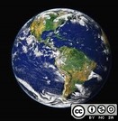
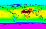
Earth is the third planet from the Sun and the only astronomical …
Earth is the third planet from the Sun and the only astronomical object known to harbor life. According to radiometric dating estimation and other evidence, Earth formed over 4.5 billion years ago. Earth's gravity interacts with other objects in space, especially the Sun and the Moon, which is Earth's only natural satellite. Earth orbits around the Sun in 365.256 solar days, a period known as an Earth sidereal year. During this time, Earth rotates about its axis 366.256 times, that is, a sidereal year has 366.256 sidereal days. Earth's axis of rotation is tilted with respect to its orbital plane, producing seasons on Earth. The gravitational interaction between Earth and the Moon causes tides, stabilizes Earth's orientation on its axis, and gradually slows its rotation. Earth is the densest planet in the Solar System and the largest and most massive of the four rocky planets.
The content works for geography both human and physical and is a …
The content works for geography both human and physical and is a good way to get to know students in their freshmen or second year in a community college setting. In addition, students get used to working with maps. Courses: geography/world cultures and other courses dealing with world population.
NGSS unit addressing the following standards:4-LS1-14-ESS 3-2This 5E lesson guides students to …
NGSS unit addressing the following standards:4-LS1-14-ESS 3-2This 5E lesson guides students to answer the following questions:How do plants’ structure and function affect their survival?How do plants impact wildfires in Oregon?
This is a mapping activity that uses the student’s schoolyard to investigate …
This is a mapping activity that uses the student’s schoolyard to investigate how rain/stormwater interacts with different surfaces and where stormwater problems may occur. Students use Next Generation Science Standards’ Science and Engineering Practices in a near-by, relevant place.
No restrictions on your remixing, redistributing, or making derivative works. Give credit to the author, as required.
Your remixing, redistributing, or making derivatives works comes with some restrictions, including how it is shared.
Your redistributing comes with some restrictions. Do not remix or make derivative works.
Most restrictive license type. Prohibits most uses, sharing, and any changes.
Copyrighted materials, available under Fair Use and the TEACH Act for US-based educators, or other custom arrangements. Go to the resource provider to see their individual restrictions.