Updating search results...

Search Resources

3918 Results

View
Selected filters:
  • Science Education Resource Center (SERC) at Carleton College
Documented Problem Solving: The Long Run Competitive Market
Conditional Remix & Share Permitted
CC BY-NC-SA
Rating
0.0 stars

During the lecture, the competitive market was introduced. A graph was used to demonstrate a competitive market in which there was an economic profit. The profit motive causes an increase in supply. As additional producers enter the market, the price of the product or service decreases. In the end, price will decrease until the long-run equilibrium situation is reached which means that the economic profit decreases to zero.

Subject:
Economics
Social Science
Material Type:
Activity/Lab
Provider:
Science Education Resource Center (SERC) at Carleton College
Provider Set:
Pedagogy in Action
Author:
Linda Wilson
Date Added:
11/06/2014
Does A River Have Rights?
Conditional Remix & Share Permitted
CC BY-NC-SA
Rating
0.0 stars

Individual students have different ethical "lines." This class discussion proceeds with a series of prompts that presents a set of scenarios that explores ethical boundaries. Students discuss right and wrong actions with respect to a river and discuss why those actions are "right" or "wrong" as well as how their ethical viewpoints vary.

(Note: this resource was added to OER Commons as part of a batch upload of over 2,200 records. If you notice an issue with the quality of the metadata, please let us know by using the 'report' button and we will flag it for consideration.)
Subject:
Biology
Life Science
Material Type:
Activity/Lab
Case Study
Homework/Assignment
Provider:
Science Education Resource Center (SERC) at Carleton College
Provider Set:
Teach the Earth
Author:
Michael Phillips
Date Added:
11/27/2021
Does Fracking Cause Earthquakes?
Conditional Remix & Share Permitted
CC BY-NC-SA
Rating
0.0 stars

Students will use the IRIS Earthquake Browser to assess the pattern of earthquakes in Arkansas before, during and after (>2011) fracking related wastewater injection. Students will use critical thinking skills to determine if earthquakes are related to fracking related activities.

(Note: this resource was added to OER Commons as part of a batch upload of over 2,200 records. If you notice an issue with the quality of the metadata, please let us know by using the 'report' button and we will flag it for consideration.)
Subject:
Biology
Life Science
Material Type:
Activity/Lab
Provider:
Science Education Resource Center (SERC) at Carleton College
Provider Set:
Teach the Earth
Author:
Renee Faatz
Date Added:
08/29/2019
Does It All Add Up?
Conditional Remix & Share Permitted
CC BY-NC-SA
Rating
0.0 stars

This lab introduces basic chemistry concepts in molecular interactions, measurements, prediction, and critical thinking.

Subject:
Chemistry
Physical Science
Material Type:
Activity/Lab
Assessment
Lesson Plan
Provider:
Science Education Resource Center (SERC) at Carleton College
Provider Set:
Pedagogy in Action
Author:
Dana Damm
Date Added:
12/13/2011
Does it Float? An Inquiry-based Activity Investigating Buoyancy
Conditional Remix & Share Permitted
CC BY-NC-SA
Rating
0.0 stars

This is an inquiry-based activity in which students will need to work together as a class to solve the following problem: they must construct a "boat" entirely out of modeling clay that is capable of supporting 150 grams of cargo without sinking.

Subject:
Physical Science
Physics
Material Type:
Activity/Lab
Assessment
Lesson Plan
Provider:
Science Education Resource Center (SERC) at Carleton College
Provider Set:
Pedagogy in Action
Author:
Sean Sletten
Date Added:
12/13/2011
Don't Just Do Something, Sit There: Suggestions for Observing in Nature
Conditional Remix & Share Permitted
CC BY-NC-SA
Rating
0.0 stars

A workshop for enabling students to sit quietly and observantly in the natural world.

(Note: this resource was added to OER Commons as part of a batch upload of over 2,200 records. If you notice an issue with the quality of the metadata, please let us know by using the 'report' button and we will flag it for consideration.)
Subject:
Biology
Career and Technical Education
Composition and Rhetoric
English Language Arts
Environmental Studies
Life Science
Material Type:
Activity/Lab
Provider:
Science Education Resource Center (SERC) at Carleton College
Provider Set:
Teach the Earth
Author:
Jean MacGregor
Date Added:
11/19/2019
Don't move a mussel: Environmental DNA (eDNA) analysis for detecting aquatic invasive species
Conditional Remix & Share Permitted
CC BY-NC-SA
Rating
0.0 stars

Students will learn field sampling and laboratory techniques to utilize environmental DNA (eDNA) as an early detection tool for invasive or rare species, with a focus on zebra mussels.

(Note: this resource was added to OER Commons as part of a batch upload of over 2,200 records. If you notice an issue with the quality of the metadata, please let us know by using the 'report' button and we will flag it for consideration.)
Subject:
Biology
Career and Technical Education
Environmental Studies
Life Science
Material Type:
Activity/Lab
Provider:
Science Education Resource Center (SERC) at Carleton College
Provider Set:
Teach the Earth
Author:
Angela Strecker
Date Added:
12/10/2020
Do the Oceans have Infinite Heat Capacity?
Conditional Remix & Share Permitted
CC BY-NC-SA
Rating
0.0 stars

This page presents a strategy for addressing a common climate misconception in the classroom, derived from The Debunking Handbook, by John Cook and Stephan Lewandowsky. This material was created by faculty as part of the CLEAN Climate Communications Workshop, held in April, 2012.

Subject:
Applied Science
Career and Technical Education
Environmental Science
Environmental Studies
Material Type:
Activity/Lab
Provider:
Science Education Resource Center (SERC) at Carleton College
Provider Set:
Teach the Earth
Author:
Laura Rico-Beck
Maureen Aylward
Paul Ruscher
Date Added:
01/20/2023
Do the Right Thing
Conditional Remix & Share Permitted
CC BY-NC-SA
Rating
0.0 stars

Earth Scientists often work independently in laboratory or field situations, and may be confronted with ethical challenges at times when their is no external scrutiny of one's conduct. How can we best train students to "do the right thing" in accordance with professional ethical standards? A number of scenarios are presented so that students must consider the context, conduct, and consequences of their actions.

(Note: this resource was added to OER Commons as part of a batch upload of over 2,200 records. If you notice an issue with the quality of the metadata, please let us know by using the 'report' button and we will flag it for consideration.)

Subject:
Biology
Life Science
Material Type:
Activity/Lab
Case Study
Provider:
Science Education Resource Center (SERC) at Carleton College
Provider Set:
Teach the Earth
Date Added:
08/17/2022
Downloading Earthquake Data from the USGS Earthquake Hazards Site for Anywhere in the World and Studying it Using ArcGIS
Conditional Remix & Share Permitted
CC BY-NC-SA
Rating
0.0 stars

The USGS Earthquake Hazards Program web site allows you to download earthquake data as an Excel spreadsheet from any area in the world over a specific time period and magnitude range. This is a fantastic resource that makes it possible to study any area you want and not be limited to canned data sets. It's also very easy to save the Excel files in a way that can be imported directly into ArcMap and then into ArcScene.

In this in-class activity, students download earthquake data from the Sumatra area and examine it first in Excel. They quickly observe that, even when they sort the spreadsheet in various ways, they can develop only a limited picture of the data. In the second part of the activity, students bring the data into ArcMap to portray it spatially, and they change the symbols to portray various attributes of the earthquakes. In the final part of the activity, students display the data in three dimensions in ArcScene. This latter is particularly powerful, because students can interactively rotate the ArcScene, which helps immensely in their abilities to visualize the depth distribution of quakes.

Although the activity focuses on Sumatra, the activity could easily be done for any area of the world. Later in the semester in this course, students download earthquake data from other areas in the world when they evaluate earthquake hazards in other regions.

You can also download a GIS Primer (Acrobat (PDF) PRIVATE FILE 1.2MB Mar30 10) that we have written, which is a simple GIS "how-to" manual for tasks including those used in this exercise.

(Note: this resource was added to OER Commons as part of a batch upload of over 2,200 records. If you notice an issue with the quality of the metadata, please let us know by using the 'report' button and we will flag it for consideration.)
Subject:
Biology
Life Science
Material Type:
Activity/Lab
Provider:
Science Education Resource Center (SERC) at Carleton College
Provider Set:
Teach the Earth
Author:
Barb Tewksbury
Date Added:
07/10/2021
Drag Coefficient Estimates Using a Smoke Wind Tunnel
Conditional Remix & Share Permitted
CC BY-NC-SA
Rating
0.0 stars

This lab exercise utilizes a small (and relatively easy to make) wind tunnel with a fog tracer that helps students visualize the flow dynamics around obstacles. In this exercise the use of cylinders perpendicular to the flow allows for estimations of drag coefficients and visualization of different Reynolds number flow patterns. Wind tunnel instructions are included.

Subject:
Applied Science
Atmospheric Science
Engineering
Environmental Science
Physical Science
Material Type:
Activity/Lab
Provider:
Science Education Resource Center (SERC) at Carleton College
Provider Set:
Teach the Earth
Author:
James King
Date Added:
01/20/2023
Drainage Basin Morphometry
Conditional Remix & Share Permitted
CC BY-NC-SA
Rating
0.0 stars

The goal of this activity is for to students to observe and quantify the inherent organization within the channel network of a single drainage basin (a la Horton, 1945). The students will use the contour-crenulation method to flesh out the channel network within a selected drainage basin. They will then use the Strahler system to deterime the stream order of each channel segment. They then measure and average various attributes (slope, length, etc.) of the channel segments, by stream order. These data will then be plotted on semi-log graph paper to illustrate the matematical relationships between channel attributes and stream order. This activity gives students practice in delineating drainage divides and channel networks on topographic maps, using map scales to measure distances on topographic maps, and graphing data using a semi-log format. In addition, they are asked to compare their "real-world" results against the classic "laws" of basin morphometry presented in their textbook. This permits a discussion of sample size and measurement error versus theoretical relationships presented in a textbook.
Designed for a geomorphology course

(Note: this resource was added to OER Commons as part of a batch upload of over 2,200 records. If you notice an issue with the quality of the metadata, please let us know by using the 'report' button and we will flag it for consideration.)
Subject:
Biology
Life Science
Material Type:
Activity/Lab
Provider:
Science Education Resource Center (SERC) at Carleton College
Provider Set:
Teach the Earth
Author:
Rick Ford
Date Added:
08/16/2019
Drainage Basins Field Lab
Conditional Remix & Share Permitted
CC BY-NC-SA
Rating
0.0 stars

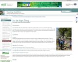
This exercise begins with a field trip to the San Gabriel Mountain foothills near our campus. Students are given a set of topographic maps and asked to follow our progress as we hike into a small drainage basin in the Claremont Wilderness Park. Through interactive discussion, we explore regional landscape and the geomorphic form, function, and processes of a drainage basin system. Students are expected to complete their assignment on drainage basin analysis during the following week, working from the maps provided. Students are asked to identify the basic landscape units in the San Gabriel Mountain foothill region, delineate a set of drainage basins, and analyze the geomorphic characteristics of these basins using longitudinal profiles and morphometric indices. From this information, they are expected to draw basic conclusions about the geomorphic processes affecting this landscape system, and its relative state of equilibrium.
Designed for a geomorphology course

(Note: this resource was added to OER Commons as part of a batch upload of over 2,200 records. If you notice an issue with the quality of the metadata, please let us know by using the 'report' button and we will flag it for consideration.)
Subject:
Biology
Life Science
Material Type:
Activity/Lab
Homework/Assignment
Provider:
Science Education Resource Center (SERC) at Carleton College
Provider Set:
Teach the Earth
Author:
Jeff Marshall
Date Added:
09/02/2020
Drainage basin patterns and stream courses
Conditional Remix & Share Permitted
CC BY-NC-SA
Rating
0.0 stars

This exercise is typically integrated with lecture during the first two days of a chapter on fluvial geomorphology.

Day 1:
The first day of class begins with a discussion of the components of a drainage basin and typical drainage basin patterns, including dendritic, parallel, trellis, rectangular, radial, annular, and multibasinal. After viewing the typical textbook diagrams of these drainage basin patterns, each student is given his/her own topographic map and a geologic map from the same region. The students are given the following instructions:

1.Write a one paragraph description of your study area, and include the following information:

Quad. name
Drainage basin pattern(s) -- in bold
Geological influence

2.Email the paragraph to me as an MS Word document by 9:00AM on [date -- next day]. I will read the paragraph, but I will not modify any wording, so make sure it is accurate and well-written.

The maps are usually distributed in the last 10 minutes of a 50-minute class period, so that the students have some time to get familiar with the maps and ask any questions that arise immediately. Recommended 7.5 minute quad.s for the exercise include:

dendritic: Effingham, IL; Alma, WI-MN
parallel: Ithaca West, NY; Antelope Peak, AZ
trellis: Waldron, AR
rectangular: Hillsboro, KY; Cumberland MD-PA-WV
radial: Mt. Rainer, WA
annular: Maverick Spring, WY
multibasinal: Whitwell, TN; Oolitic, IN

The Website http://rockyweb.cr.usgs.gov/outreach/featureindex.html is also a useful reference for other topographic maps.

Day 2:
On the second day of class, we discuss the initiation of channels and basin morphometry. After lecturing on topics like tractive force, micropiracy, cross-grading, and bifurcation, we discuss typical stream courses (i.e., insequent, consequent, subsequent, obsequent, and resequent). In the last 5 minutes of class, the paragraphs from the previous day are redistributed in such a way that every student has a paragraph written by one of their peers and a new set of maps. The students are given the following instructions:

1.Rewrite/edit what you have been given, if necessary, to emphasize the bolded drainage pattern.
2.Decide whether the stream patterns are representative of consequent, insequent, or subsequent stream courses.
3.Explain your reasoning using the geologic map.

Discuss the influence of the resistance of geologic materials on the stream course.
Discuss the influence of slope on the development of the stream course.

4.Email the paragraph to me as an MS Word document by 9:00AM on [date -- next day].

Once final paragraphs are submitted, they are redistributed to the entire class so that all students have a complete set of paragraphs describing a variety of drainage basin patterns and stream courses from a variety of geologic settings. Maps remain in the classroom for the duration of the term so that students can reference them if they choose to.
Designed for a geomorphology course
Has minimal/no quantitative component

(Note: this resource was added to OER Commons as part of a batch upload of over 2,200 records. If you notice an issue with the quality of the metadata, please let us know by using the 'report' button and we will flag it for consideration.)
Subject:
Biology
Life Science
Material Type:
Activity/Lab
Homework/Assignment
Provider:
Science Education Resource Center (SERC) at Carleton College
Provider Set:
Teach the Earth
Author:
Sue Swanson
Date Added:
09/02/2020
Drawing Structural and Isopachous Maps
Conditional Remix & Share Permitted
CC BY-NC-SA
Rating
0.0 stars

This activity has 3 maps with real stratigraphic data recorded adjacent to drill holes in the Illinois Basin. Students contour the structural data. They may also contour the associated thickness data or they can just look at the trends of the thickness data relative to the structures on their completed structure map.

Subject:
Geology
Physical Geography
Physical Science
Material Type:
Activity/Lab
Homework/Assignment
Provider:
Science Education Resource Center (SERC) at Carleton College
Provider Set:
Teach the Earth
Author:
Janis Treworgy
Date Added:
01/20/2023
Dredge Planning Using Sub-Bottom SONAR
Conditional Remix & Share Permitted
CC BY-NC-SA
Rating
0.0 stars

This project is designed to give students valuable geophysical experience in conducting an environmental assessment of a real-world problem. A scenario is developed in which students work for "Viking Consulting, LLC" as an environmental geologist. The company has been hired by the City of Salem to assess an appropriate confined aqueous disposal (CAD) cell location for contaminated dredge spoils from a proposed dredging project of the South River, Salem, MA. Students utilize sub-bottom SONAR technology to calculate volume of dredge spoils and potential CAD cell locations and analyze which location can accommodate the contaminated material.

(Note: this resource was added to OER Commons as part of a batch upload of over 2,200 records. If you notice an issue with the quality of the metadata, please let us know by using the 'report' button and we will flag it for consideration.)

Subject:
Biology
Life Science
Material Type:
Activity/Lab
Homework/Assignment
Provider:
Science Education Resource Center (SERC) at Carleton College
Provider Set:
Teach the Earth
Author:
Brad Hubeny
Date Added:
08/09/2019
Drinking Water Quality: An Interdisciplinary Research Experience of Introductory Geology and Chemistry Classes
Conditional Remix & Share Permitted
CC BY-NC-SA
Rating
0.0 stars

At the University of Nebraska at Omaha, we have involved students in introductory Geology and Chemistry classes in an interdisciplinary study of drinking water quality. The goals of this project are to introduce the students to the scientific method, get them to actually "do" relevant science, and show how science affects their lives. We have also used this exercise to help some students overcome their fear of science by allowing them to actively learn science, rather than absorb it in a passive fashion.

(Note: this resource was added to OER Commons as part of a batch upload of over 2,200 records. If you notice an issue with the quality of the metadata, please let us know by using the 'report' button and we will flag it for consideration.)

Subject:
Biology
Chemistry
Life Science
Physical Science
Material Type:
Lesson Plan
Provider:
Science Education Resource Center (SERC) at Carleton College
Provider Set:
Teach the Earth
Date Added:
09/22/2022
Driving Across Town for Cheaper Gas -- A Cost/Benefit Analysis
Conditional Remix & Share Permitted
CC BY-NC-SA
Rating
0.0 stars

Spreadsheets Across the Curriculum module. Students build a spreadsheet to explore the trade-offs between "bargain-priced" gas vs. the extra mileage needed to get it. A modeling problem.

Subject:
Economics
Social Science
Material Type:
Activity/Lab
Provider:
Science Education Resource Center (SERC) at Carleton College
Provider Set:
Pedagogy in Action
Author:
Gary Franchy
Date Added:
11/06/2014
Driving Through Geologic Time
Conditional Remix & Share Permitted
CC BY-NC-SA
Rating
0.0 stars

An analogy of the Earth's history to a cross-country drive.

(Note: this resource was added to OER Commons as part of a batch upload of over 2,200 records. If you notice an issue with the quality of the metadata, please let us know by using the 'report' button and we will flag it for consideration.)

Subject:
Biology
Geoscience
Life Science
Mathematics
Measurement and Data
Physical Science
Statistics and Probability
Material Type:
Activity/Lab
Provider:
Science Education Resource Center (SERC) at Carleton College
Provider Set:
Teach the Earth
Author:
Eric Baer
Date Added:
08/25/2019