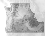
This 2018 edition is the first to be released in a digital, fully-interactive format, designed to highlight facets of the Pacific Northwest landscape with novel approaches to data presentation. Where previous editions of the atlas were designed to ask and answer questions, this atlas serves as a platform for the geographically curious to explore the region, providing as many critical questions as it does critical answers.
Beyond this page are maps of the familiar and the unfamiliar. Migration maps highlight human movement between the Pacific Northwest and the rest of the United States; a wildfire timeline chronicles the year-to-year spread of modern and historical fires; and the watershed guide abandons traditional political boundaries in favor of natural, hydrological borders. All data in the atlas were gathered from publically accessible sources, compiled using open-source software and coding libraries. This is an atlas designed to be open, responsive, and to satisfy the geographic curiosity of any and all interested.
- Subject:
- Physical Geography
- Physical Science
- Material Type:
- Data Set
- Author:
- Institute for Natural Resources
- Oregon State University Libraries and Press
- Date Added:
- 10/30/2018

